FULL GRAMPIANS PEAKS TRAIL
13 Days 5950 ex Halls Gap

Accommodation
1 Night Hotel
11 Nights Tent
Transportation
All on foot

Included Meals
12 Breakfasts
12 Lunches
12 Dinners

Trip Grade
Category 3
High Heart Rate Holiday
It was early to mid-morning, the sweat on my brow suggested things were heating up (the forecast suggested it was only going to get hotter) and we’d just started our first true ascent of the day since leaving the Borough Huts campsite behind.
Chris was in the lead this time, talking almost non-stop as usual, when a few moments had passed and I realised that but for the crunch of my boots, it was deathly quiet.
Finally looking up, Chris was there, standing motionless.
Gazing past him, there, staring back at him, and then turning its attention towards me, was a huge Kangaroo!
It felt like an age (but in truth was probably seconds as opposed to minutes), but the Kangaroo just chewed away on whatever it had foraged from the path, took a last look before bounding away.
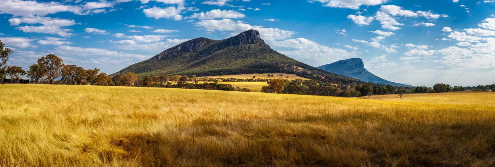
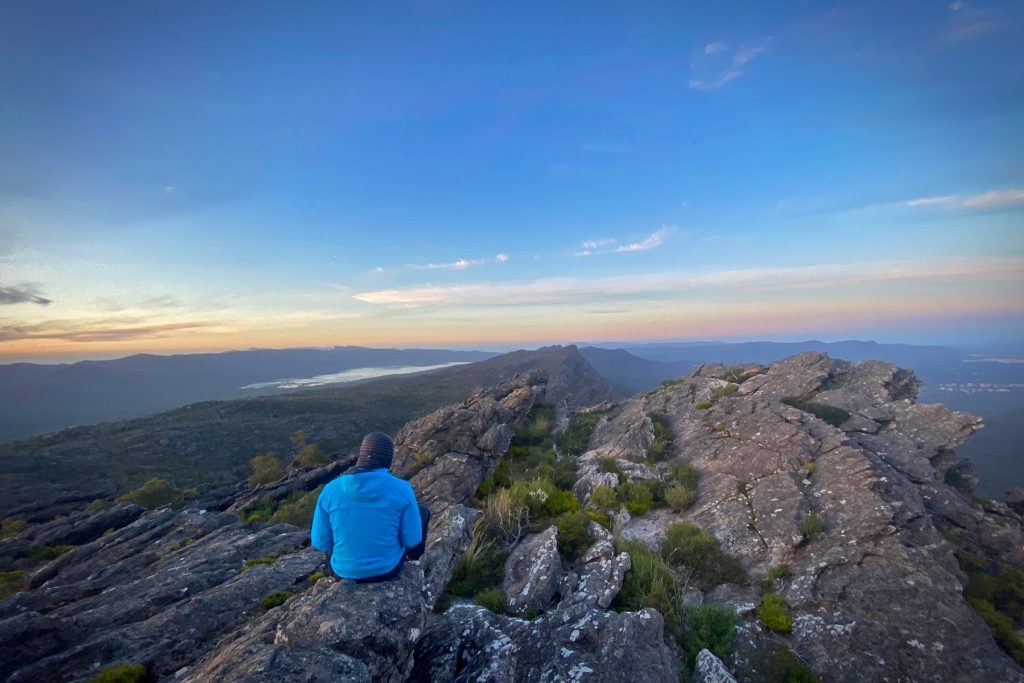
5000 meters up, 5000 meters down, 160 kilometers, 11 campsites, 450 million years in the making, home to the Jardwadjali and Djab wurrung peoples for thousands of years and only 3 hours from Melbourne. Who would have thought such an epic adventure was just on our doorstep. The Grampians Peaks Trail.
The food was fabulous and was even spoilt with wine. Overall a fabulous experience with great company a great guide and little for us to do except walking and enjoy the scenery. The Grampians are beautiful!
Cherie – Australia
The Grampians Peaks Trail End to End (GPT E2E) expedition is not for the faint-hearted.
Its 13 days on the trail will test your stamina and resolve as every peak and turn opens a new view that hopefully inspires you to keep going.
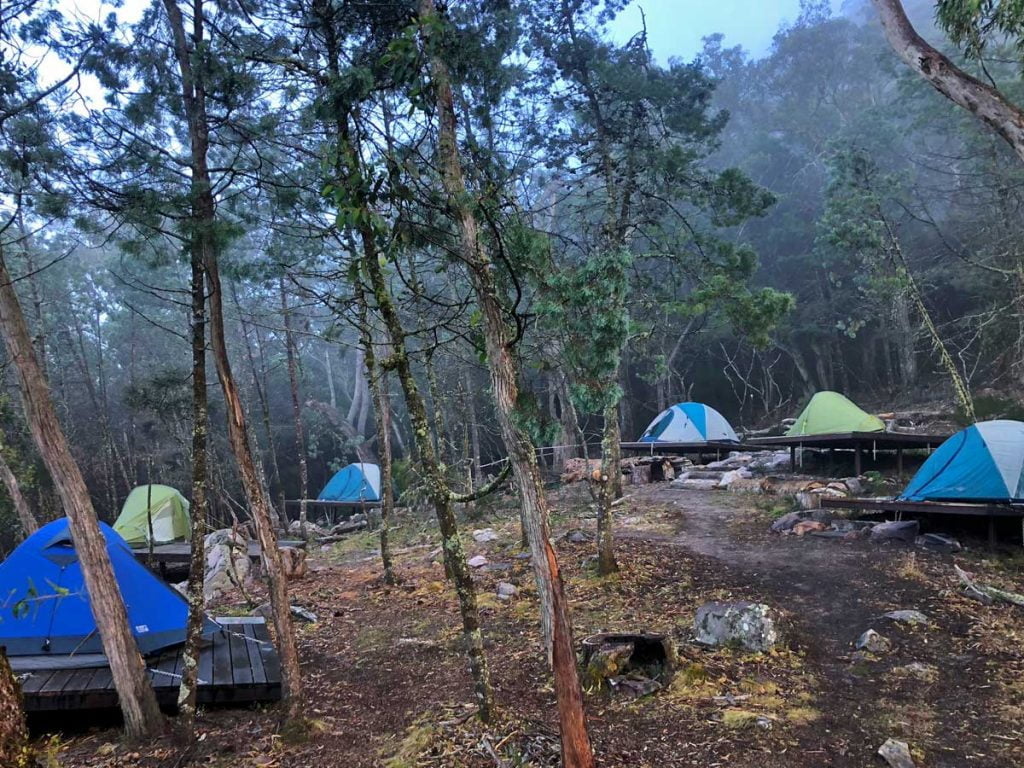
Covering the entire length of the GPT from north to south, we’ll walk each day, and with the exception of the 4th night in Halls Gap, camping at the on-trail hiker camps in lightweight hiking tents fully exposed to the constantly changing personality of the Gariwerd landscape.
Over the course of the trek, we’ll bear witness to constant changes to the environment, experience being in the remote, and hopefully, gain a better understanding and appreciation of the land.
The northern and central sections of the trail have relatively good access and amazing facilities at camp, while the much more remote and wild central section has limited access and less shelter at camps leaving you more exposed to the will of the mountains.
Rising out of the flat sweep of Western Victoria, the ancient Grampians mountain range extends for 160 km north to south, creating a series of dramatic escarpments that reach heights of over 1100 meters.
We’ll begin our journey at the main GPT Trailhead at Mount Zero, climb Mount Staypleton and then continue southward for 13 days until we reach Dunkeld. Each night at our hiker camps, we will rest, enjoy a freshly cooked trail meal and sleep (fingers crossed) under a blanket of stars.
No matter your level of hiking experience, our passionate local team will guide and support you through this journey to explore their backyard.

The Journey
Meet your guide and the expedition team at Halls Gap for a briefing and gear check before a transfer to the beginning of the GPT at Mount Zero picnic area. The heart rate will rise quickly as we ascend ‘Flat Rock’ and, again when we get to the top and get our first world-class viewpoint – just 10 minutes in!
We’ll descend and navigate our way through the Stapylton Amphitheatre before skirting our way around and up Mount Stapylton itself. For the foot-sure and brave, there is a short scramble to the summit to gain 360-degree views and a sneak peek of the next day’s walk in the distance.
After a fresh trail lunch, we’ll head southwards along the mostly high ground before descending into a valley and reaching Barigar Hiker Camp. After settling in we can take a short side trip to visit the camp’s namesake Barigar Falls. (L,D)
We’ll begin our day with a hearty breakfast and then depart camp. Our first steps take us along the base of the Rock Wall, an impressive several km long escarpment hidden away in a valley. As the cliff line reduces, we begin to ascend its ridge to cross over into Roses Gap.
As we begin to ascend the lower slopes of Gar (Mount Difficult) we will find and begin to follow a small, unsuspecting watercourse – seasonal and rainfall dependent. Over the next few km, we will witness this watercourse cascading over a series of drops, each one more spectacular than the last.
After we gain the top of the last waterfall, we’ll head towards the ‘Pacific Ocean Wall’, a cliff ‘as big as the pacific ocean’, ascend its flank via a superbly built stone stairway and continue climbing up to Briggs Bluff. With most of the ascent completed, from here we can traverse our way along the high ground before arriving at Gar Hiker Camp and its breathtaking views. (B,L,D)
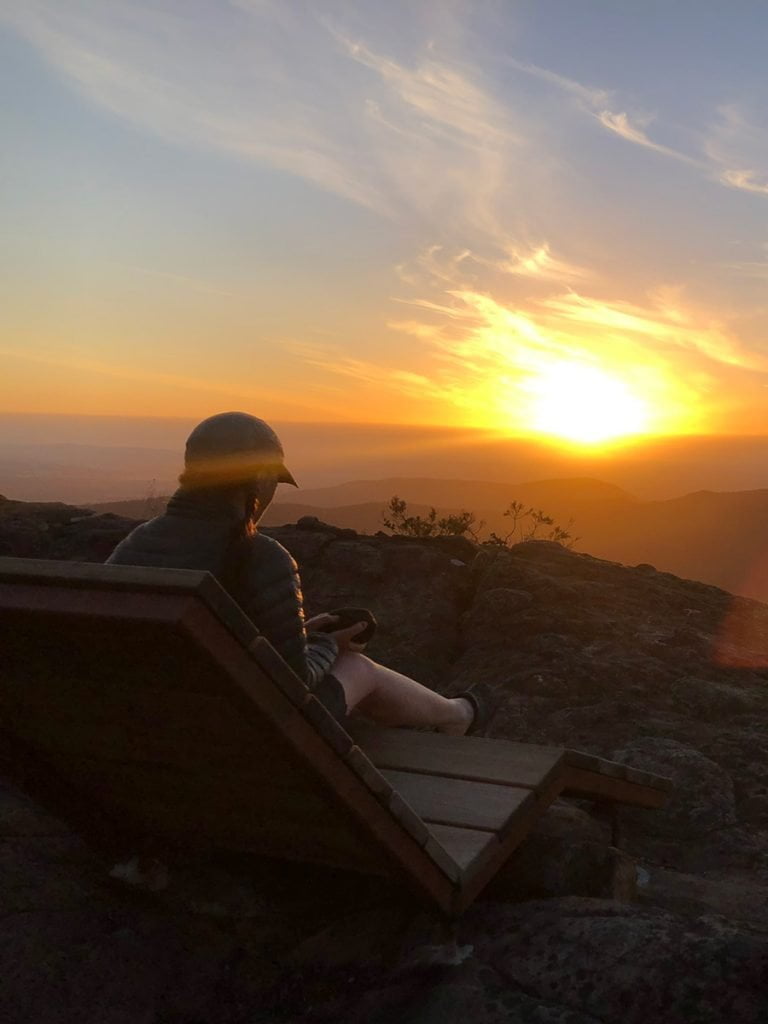
An early start this morning as we head up to the summit of Gar for a sunrise (weather permitting) like few others. We’ll then return to camp for breakfast, before resuming our trek.
We will sharply descend the eastern slopes of Gar, cross the northern end of the Werdug (Wartook) Basin and gain the ridge of the eastern flank of the Mount Difficult massif.
Continuing south along this high ground we will eventually reach Werdug Hiker Camp with stunning views overlooking Lake Wartook and a clear line of sight all the way back to the top of Gar where we stood that morning.
We will continue along the eastern flank of Mount Difficult, before we meander down towards the town of Halls Gap.
Before our arrival, we’ll head out to the end of Chautauqua Peak for an incredible view down the valley before finishing our descent into Halls Gap.
We will walk all the way to our accommodation for the night where we can shower and freshen up before enjoying a nice dinner out in the town. (B,L,D)
We’ll farewell the relative comfort of Halls Gap after breakfast, the last time we’ll see a town until we reach Dunkeld in over a weeks time.
Winding our way up the Wonderland Range we will pass iconic sites such as the Venus Baths, Grand Canyon, Silent Street and the Pinnacle.
After traversing some high ground, we’ll pop over and descend to the saddle between the Wonderland Range and Mount Rosea.
It’s then a gentle climb of Mount Rosea’s northern shoulder to find the stunning Stoney Creek Hiker Camp. (B,L,D)
This morning starts with an exciting climb over some really interesting terrain, passing the Gate of the East Wind we will reach the summit of Mount Rosea at 1009 m above sea level.
The views from here are stunning, providing a wonderful vantage point from which to take in Lake Bellfield, and on clear days, much of the flatlands beyond.
After a long descent into the valley, we leave the Serra Range by crossing the Grampians Tourist Road and begin our ascent towards Mount William.
Luckily, most of that is saved for tomorrow as it’s only another 1.2 km to Barri Yalug, our first ‘backcountry hiker camp’ – more remote hiker camps with limited shelter.
The next 5 nights of our expedition are in backcountry camps and will be a little more exposed to the elements. It’s a necessary compromise to experience some of the most remote and wild parts of the Gariwerd range. (B,L,D)
A short steep descent out of camp will lead us to cross Barney Creek at 320m above sea level and the ensuing short flat stretch provides a period of brief respite, before the longest continual climb anywhere along the trail.
From Barney Creek is more or less all uphill until Redman Bluff at 1017 m.
It’s a long gradual climb, taking us from rugged bushland, to large open rock areas.
Along the way, we’ll see parts of an old aqueduct system that used to feed water to nearby towns before the construction of Lake Bellfield.
Passing some of the ‘Seven Dials’ (rocky escarpments that gaze down from above) we’ll continue on to finally reach Redman Bluff and take a well-earned rest before descending to a saddle and then a final gentle climb to Duwul Hiker Camp. (B,L,D)
Today we walk one of the most exposed sections of the Grampians Peak Trail with the most amount of time spent at higher elevations.
We’ll start by climbing up to Mt William (the highest peak in all of Gariwerd at 1167m), before heading south and down to Boundary Gap at 878m, which separates Mt William from the Major Mitchell Plateau.
This descent and ascent contain some of the most challenging terrain on the whole GPT.
Once we gain the plateau we will undulate across rocks and steel mesh walkway, passing First Wannon Creek and reaching the highest point on the plateau, Durd Durd, equal in height to Mount William at 1167 m, and marked by a rock cairn.
We will continue south to Banksia Hill at 1103m, across the banksia ridgeline where the trail hops across large boulders before descending to open grassy woodland, reminiscent of an alpine meadow.
While Durd Durd Hiker Camp is much more sheltered than most of the day’s walk, it still sits at 855m above sea level and along with Duwul Hiker Camp are the 2 highest camps and most likely to receive snow in winter and even spring. (B,L,D)
A new landscape unfolds as we descend from the highest parts of the Mount William Range and continue to traverse southward, down into sheltered woodland valleys.
Passing through previously untracked areas of the lower Mt William range, it offers up some of the most rugged ridgeline rock walking and views of the incredible Serra Range to the west.
This section is fantastic for late winter and spring wildflowers.
Watch for the red “spider flowers” of Flame Grevillia, typically in bloom between April and November.
To the east is the area’s farmland and scattered lakes and wetlands – important habitat to wildlife, including threatened species such as Australia’s largest flying bird, the Brolga.
This ridge walking leads us over the day to Yarram Hiker Camp to rest up for the night. (B,L,D)
The Mount William Range presents its last ups and downs, before we then enjoy a long flat(ish) walk, passing through ancient old-growth forests and lower swampland plains.
Stands of native Oyster Bay Pines (Callitris rhomboidea) are commonplace along the way.
We’re afforded views of farmland to the east and south-east, and the countless swamps, lakes and wetlands as well as the dramatic Serra Range to the west.
Climbing the last little blips of the Mount William Range, we’ll settle into Wannon Hiker Camp for the night in a reclaimed farmland gully. (B,L,D)
Today begins with incredible open grassland and a combination of gentle trail and steel boardwalks, through large areas of Grass Tree (Xanthorrhoea Australis), swampy river flats and open heathy forest.
Much of the landscape here feels other worldly, almost Jurrasic.
The thick understory provides important habitat for threatened small mammals such as the Long-nosed Potoroo, Southern Brown Bandicoot and Heath Mouse.
Shortly after passing the Griffin Fireline we will cross back over the Grampians Tourist Road and climb through the incredible forest back onto the Serra Range.
Saddles of old-growth forest, sheer eastern faces and expansive views to the western Victoria Range will bring us to Djardji-djawara, our second last hiker camp on a small rocky knoll. (B,L,D)
From Djardji-djawara we cross Cassidy Gap and begin climbing a short but spicy trail up Signal Peak. With varied terrain from steps to boulders, this climb is not to be underestimated.
Signal Peak is one of the great peaks of the Serra Range that, prior to the construction of the GPT never had a trail leading to the top.
From its summit, we’re provided one of the most spectacular vantage points from which to view Mount Abrupt in the early morning light.
Our journey continues south, dropping down from Signal Peak to a long saddle covered in forest, before gradually climbing, and then more abruptly up the aptly named peak.
The forested areas of exposed ridgelines on the southern Serra Range, provide a great contrast from the vegetation seen early on the trek, a true reflection of the physical (and for some metaphorical) distance we have travelled.
We’ll visit the incredible summit of Mount Abrupt, before descending to Mad-dadjug Hiker Camp, situated on its southern shoulder. (B,L,D)
Our last morning on the trail! After a quick bite and a pot of coffee before dawn, we’re off to carefully make the steep descent from Mt Abrupt, passing a reservoir and then climbing over Bainnggug (the Piccaninny) where we hope to catch the sunrise and breakfast.
When we’re ready to continue, we will cross Victoria Valley Road and begin the final climb of the GPT over Mt Sturgeon (Wurgarri).
Mt Sturgeon towers over our destination (Dunkeld) as well as offering stunning 360 degree views.
The landscape reveals stories of country. Looking northward we can see the sedimentary sandstone of Gariwerd and draw a line with our finger along our path, with at least the last 5 days of our journey visible.
To the south, basalt lava flows over volcanic plains. Volcanoes nearby at Budj Bim National Park and Mt Gambier are only 5000 years old, while the oldest dated Aboriginal rock shelter in Gariwerd is 22,000 years old.
Our journey is complete by a steep descent into the farmland below and wandering through open old-growth Red Gum woodland to reach Dunkeld.
After a celebratory lunch, we will load onto our private transport and transfer back to Halls Gap. (B,L,D)
A Few Important Notes
Private Expeditions? If our dates don’t suit and you have a group of 6 or more we can run this expedition on any date you wish.
Best time to travel? From mid-October to mid-May, however we suggest avoiding the Christmas School Holidays as Christmas until mid-February can be hot and busy.
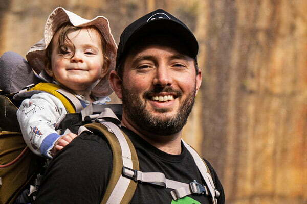
I love the Grampians so much I moved to Halls Gap so I could explore this incredible landscape every day. If you love walking in nature, hiking to a summit to get an amazing view of an amazing ancient land, then you are going to love this trek. No need to worry about packing tents and food, we take care of everything so you can enjoy a great getaway in the Australian bush. By the way, I’m the one with the beard in the photo.
Adrian Manikas
Guide
Includes
- Qualified and experienced local guides/campsite hosts.
- 11 nights in lightweight hiking tents at GPT hiker camps – twin share.
- 1 nights accommodation in Halls Gap on night 4 – twin share
- Fresh and healthy camp cooked meals.
- All meals on the trail.
- Any required transfers.
- Group safety equipment such as a first aid kit and satellite phone.
Excludes
- Personal clothing and equipment (including backpack, mattress and sleeping bag).
- Personal medical and evacuation/ambulance insurance – highly recommended.
- Meals in towns.
- Accommodation before and after the hike.

Camping on the Grampians Peaks Trail
The Grampians Peaks Trail is a camping and wilderness trek. For 11 nights we will be camping in the Australian bush. All campsites have compostable toilets (no flushing) and areas where we all can eat breakfast and dinner.
Your tents will be set up for you. Each tent accommodates 2 people and there is plenty of room for you to store your bags and boots.
You will need to carry all your items with you along the trail. On Day 4 we will be overnighting in Halls Gap so there is a chance you can carry a lighter pack for the first few days and pick up essential items for the post-Halls Gap sections. You pack will weigh between 9-12 kgs.
Getting to Halls Gap
Halls Gap is about 3 hours drive west of Melbourne. Our hiking on Day 1 will start at around 9 am, so if you can get to Halls Gap by then, then you could drive up to Halls Gap on the morning of Day 1. However, many trekkers opt to arrive in Halls Gap the night before. If this is something you are planning, please let us know as we have several recommendations for places to stay in and around town.
One of our passions is food so we think you will love our camp menu.
No matter where you are in the world and what you are doing, if you have an empty stomach, you simply cannot enjoy yourself. And we believe that great food helps make a great trek. It doesn’t matter if we are camping in the remote, that is no excuse for bad food.
So we have developed a great menu for your trek including wraps made fresh in Halls Gap, cured meats, olives, and cheeses all sourced in and around the area, and maybe a drop or two of local wine just to help us wash it all down.
You will be walking all day, so your mind and body needs delicious homemade food to reenergise you for the next day. We are sure you will love our food.
PS If you have any dietary requirements just let us know we can provide what you need.
These trips might also interest you...
4 Day Grampians Peak Trail
If 12 days is too long, you can still explore the incredible Grampians National Park and the Grampians Peak Trail on our 4 day hike. Trek to ridge lines that will give you superb views over this rugged and dramatic landscape and each night be looked after at camp by our guide team. This is a great weekend getaway!
Weekender
6 Day Great Ocean Walk
Immerse yourself not only in one of Australia’s most dramatic landscapes but also the incredible history of Shipwreck Coast. Our fully guided and catered Great Ocean Walk will have you hiking deserted beaches, stand atop mainland Australia’s highest sea cliffs and spend quality time with like minded friends.
Victorian Alpine Traverse
The Victorian Alps come alive during the warmer months of the year to provide us with an incredible adventure. We will traverse the Victorian High Country from the State’s highest peak, Mt Bogong, to its second highest peak, Mt Feathertop. This is a great alpine mountain trek right here in Victoria.